Geolocate

Puebl Libre de Azope topographic map

Click on the map to display elevation.

About this map

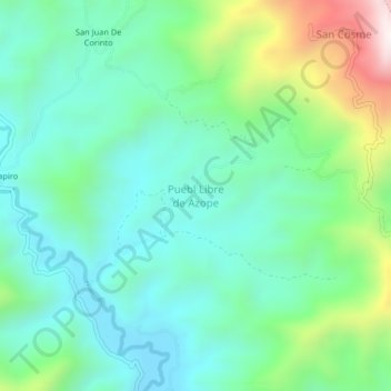
Name: Puebl Libre de Azope topographic map, elevation, terrain.

Location: Puebl Libre de Azope, Satipo, Junín, Perú (-11.26628 -74.74495 -11.22628 -74.70495)

Average elevation: 1,022 m

Minimum elevation: 795 m

Maximum elevation: 1,660 m

Other topographic maps

Click on a map to view its topography, its elevation and its terrain.

Plaza Mayor de Satipo

Perú > Junín > Satipo

Average elevation: 669 m

Plaza de Armas Santa Leonor

Perú > Junín > Satipo

Average elevation: 637 m

Gear up for your next adventure:

🎒Fully Waterproof Backpack - Total protection for photography gear and electronics
Camping Coffee Maker - Brew fresh coffee anywhere on the topographic map
🥾Hiking Boots - Sturdy boots providing ankle support and traction on rugged trails
🧥Softshell Hiking Jacket - The perfect balance of wind protection and breathability
🧦Crew Hiking Socks - Comfortable socks for long-distance hikes

As an Amazon Associate, this site earns from qualifying purchases at no extra cost to you.