
Make a donation
Gear up for your next adventure:
As an Amazon Associate, this site earns from qualifying purchases at no extra cost to you.
Tieringen topographic map
Click on the map to display elevation.
Make a donation
Gear up for your next adventure:
As an Amazon Associate, this site earns from qualifying purchases at no extra cost to you.
Tieringen
Steilabfahrt neben dem Lochenpass Startpunkt Abzweig Jugendherberge. Statt wie bei Radwegen üblich direkt neben asphaltierten Kehren von der Passhöhe hinabzufahren, wird die Strecke als Steilabfahrt kreuzungsfrei neben den Kehren geführt.
Make a donation
Gear up for your next adventure:
As an Amazon Associate, this site earns from qualifying purchases at no extra cost to you.
About this map
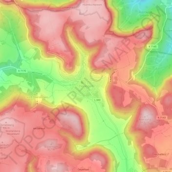
Name: Tieringen topographic map, elevation, terrain.
Average elevation: 864 m
Minimum elevation: 685 m
Maximum elevation: 965 m
Make a donation
Gear up for your next adventure:
As an Amazon Associate, this site earns from qualifying purchases at no extra cost to you.
Other topographic maps
Click on a map to view its topography, its elevation and its terrain.
Geyerbad
Deutschland > Baden-Württemberg > Zollernalbkreis > Meßstetten > Geyerbad
Average elevation: 873 m
Make a donation
Gear up for your next adventure:
As an Amazon Associate, this site earns from qualifying purchases at no extra cost to you.