
Make a donation
Gear up for your next adventure:
As an Amazon Associate, this site earns from qualifying purchases at no extra cost to you.
Breetze topographic map
Click on the map to display elevation.
Make a donation
Gear up for your next adventure:
As an Amazon Associate, this site earns from qualifying purchases at no extra cost to you.
Breetze
Breetze liegt in etwa 90 m Höhe auf einem Geestrücken innerhalb der Breetzer Berge, wo sich unweit von Breetze der Telegraphenberg befindet. Die Breetzer Berge werden zu den Endmoränen gezählt. Geographisch liegt Breetze ungefähr in der Mitte zwischen den Dörfern Neu Süttorf, Nindorf, Ellringen und dem Hauptort Bleckede.
Make a donation
Gear up for your next adventure:
As an Amazon Associate, this site earns from qualifying purchases at no extra cost to you.
About this map
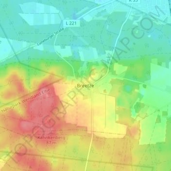
Name: Breetze topographic map, elevation, terrain.
Location: Breetze, Bleckede, Lüneburg, Niedersachsen, 21354, Deutschland (53.24446 10.68685 53.28446 10.72685)
Average elevation: 41 m
Minimum elevation: 9 m
Maximum elevation: 87 m
Make a donation
Gear up for your next adventure:
As an Amazon Associate, this site earns from qualifying purchases at no extra cost to you.