
Make a donation
Gear up for your next adventure:
As an Amazon Associate, this site earns from qualifying purchases at no extra cost to you.
Tiefenbronn topographic map
Click on the map to display elevation.
Make a donation
Gear up for your next adventure:
As an Amazon Associate, this site earns from qualifying purchases at no extra cost to you.
Tiefenbronn
The municipality (Gemeinde) of Tiefenbronn covers 14.79 square kilometers (5.71 sq mi) of the Enzkreis, a district of Baden-Württemberg, Germany. It is located on the edge of the Black Forest and the Upper Gäu [de]. The buntsandstein of the Röt Formation, under the Black Forest, extends into the municipal area from the west as far east as the border with Heimsheim. North and south of the buntsandstein are the wooded and karstified hills of muschelkalk of the Heckengäu. The main watercourse is the Würm, a tributary of the Enz that flows through Tiefenbronn in several meanders. The lowest elevation above sea level, 325 meters (1,066 ft) Normalnull (NN), is found where the Würm forms the border with Pforzheim. The highest elevation is 526 meters (1,726 ft) NN, on the northern slope of the Büchelberg.
Make a donation
Gear up for your next adventure:
As an Amazon Associate, this site earns from qualifying purchases at no extra cost to you.
About this map
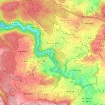
Name: Tiefenbronn topographic map, elevation, terrain.
Average elevation: 448 m
Minimum elevation: 325 m
Maximum elevation: 536 m
Make a donation
Gear up for your next adventure:
As an Amazon Associate, this site earns from qualifying purchases at no extra cost to you.
Other topographic maps
Click on a map to view its topography, its elevation and its terrain.
Holzbachtal
Germany > Baden-Württemberg > Enzkreis > Straubenhardt > Langenalb
Average elevation: 449 m
Make a donation
Gear up for your next adventure:
As an Amazon Associate, this site earns from qualifying purchases at no extra cost to you.