Geolocate

Ciutadella topographic map

Click on the map to display elevation.

About this map

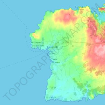
Name: Ciutadella topographic map, elevation, terrain.

Location: Ciutadella, Menorca, Balearic Islands, Spain (39.92131 3.79085 40.06292 3.98729)

Average elevation: 23 m

Minimum elevation: 0 m

Maximum elevation: 125 m

Other topographic maps

Click on a map to view its topography, its elevation and its terrain.

Binidalí

Spain > Balearic Islands > Menorca > Maó

Average elevation: 21 m

Tom de Biniarroi

Spain > Balearic Islands > Menorca > Alaior

Average elevation: 79 m

Son Blanc

Spain > Balearic Islands > Menorca > Ciutadella > sa Caleta

Average elevation: 11 m

es Còdol

Spain > Balearic Islands > Menorca > Alaior

Average elevation: 27 m

Son Oleo

Spain > Balearic Islands > Menorca > Ciutadella

Average elevation: 13 m

Cala Galdana

Spain > Balearic Islands > Menorca > Ferreries

Average elevation: 34 m

Punta Prima

Spain > Balearic Islands > Menorca

Average elevation: 13 m

Son Bou

Spain > Balearic Islands > Menorca > Alaior > Son Bou

Average elevation: 27 m

Cala Morell

Spain > Balearic Islands > Menorca > Ciutadella > Cala Morell

Average elevation: 40 m

Gear up for your next adventure:

🛶Kayak Dry Bag - Waterproof storage for kayaking adventures
🥾Trail Running Boots - Durable shoes designed for trail running
Lightweight Backpacking Tent - Compact tent for efficient hiking trips
Camping Tent - Weather-resistant tents suitable for 2 to 6 people
🦟Insect Repellent - Keep mosquitoes and black flies away in wooded areas

As an Amazon Associate, this site earns from qualifying purchases at no extra cost to you.