
East Fork Courtney Creek topographic map
Interactive map
Click on the map to display elevation.
About this map
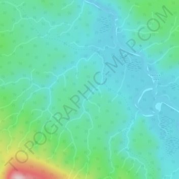
Name: East Fork Courtney Creek topographic map, elevation, terrain.
Average elevation: 940 m
Minimum elevation: 880 m
Maximum elevation: 1,177 m
Other topographic maps
Click on a map to view its topography, its elevation and its terrain.
Giscome
Canada > British Columbia > Area F (Willow River/Upper Fraser) > Giscome
Giscome, Area F (Willow River/Upper Fraser), Regional District of Fraser-Fort George, British Columbia, Canada
Average elevation: 629 m
Purden Lake
Canada > British Columbia > Area F (Willow River/Upper Fraser)
Purden Lake, Area F (Willow River/Upper Fraser), Regional District of Fraser-Fort George, British Columbia, Canada
Average elevation: 922 m