Geolocate

Longoni topographic map

Click on the map to display elevation.

About this map

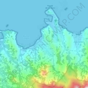
Name: Longoni topographic map, elevation, terrain.

Location: Longoni, Koungou, Mayotte, 97600, France (-12.75449 45.14316 -12.71449 45.18316)

Average elevation: 57 m

Minimum elevation: -5 m

Maximum elevation: 362 m

Gear up for your next adventure:

🧴Sunscreen SPF - Broad-spectrum sunscreen for outdoor activities
🧥Waterproof Jacket - Lightweight rain jackets for hiking and outdoor activities
🏕️Camping Hammock - Integrated protection for sleeping between trees
💧Collapsible Water Bottle - Space-saving water bottle for outdoor activities
🥾Light Trekking Boots - Supportive boots for multi-day treks

As an Amazon Associate, this site earns from qualifying purchases at no extra cost to you.