
Thank you for supporting this site ❤️
Make a donation
Make a donation
Gear up for your next adventure:
As an Amazon Associate, this site earns from qualifying purchases at no extra cost to you.
Rangen topographic map
Click on the map to display elevation.
Thank you for supporting this site ❤️
Make a donation
Make a donation
Gear up for your next adventure:
As an Amazon Associate, this site earns from qualifying purchases at no extra cost to you.
Rangen
Der Weiler liegt im Nordwesten der naturräumlichen Landschaftseinheit Gräfenberger Flächenalb etwa vier Kilometer westnordwestlich von Gräfenberg auf einer Höhe von 486 m ü. NHN.
Thank you for supporting this site ❤️
Make a donation
Make a donation
Gear up for your next adventure:
As an Amazon Associate, this site earns from qualifying purchases at no extra cost to you.
About this map
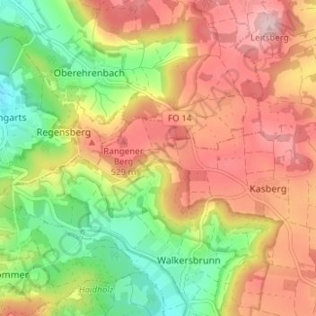
Name: Rangen topographic map, elevation, terrain.
Average elevation: 458 m
Minimum elevation: 341 m
Maximum elevation: 569 m
Thank you for supporting this site ❤️
Make a donation
Make a donation
Gear up for your next adventure:
As an Amazon Associate, this site earns from qualifying purchases at no extra cost to you.