Geolocate

Biking topographic map

Click on the map to display elevation.

About this map

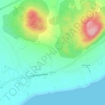
Name: Biking topographic map, elevation, terrain.

Location: Biking, Dauis, Bohol, Central Visayas, 6339, Philippines (9.58586 123.82686 9.61106 123.85587)

Average elevation: 57 m

Minimum elevation: 0 m

Maximum elevation: 187 m

Gear up for your next adventure:

🧰Survival Kit - Essential gear for emergencies in the wilderness
🛁Quick-Dry Microfiber Towel - Space-saving towel that dries rapidly on the move
🥾Trail Running Shoes - Lightweight and durable shoes for trail running
🥤Collapsible Travel Cup - Saves space and weight in your mess kit
🔨Vehicle Emergency Tool - Safety tool for remote road trips to trailheads

As an Amazon Associate, this site earns from qualifying purchases at no extra cost to you.