
Karnataka topographic map
Interactive map
Click on the map to display elevation.
About this map
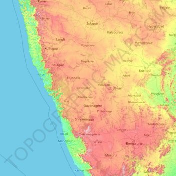
Name: Karnataka topographic map, elevation, terrain.
Location: Karnataka, India (11.59456 74.05439 18.47673 78.58808)
Average elevation: 386 m
Minimum elevation: -1 m
Maximum elevation: 1,771 m
Other topographic maps
Click on a map to view its topography, its elevation and its terrain.
Holenarasipura
India > Karnataka > Holenarasipura
Holenarasipura, Hole Narasipura taluk, Hassan district, Karnataka, 573211, India
Average elevation: 855 m