Geolocate

Montauk topographic map

Click on the map to display elevation.

About this map

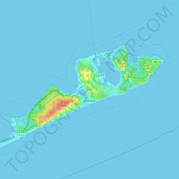
Name: Montauk topographic map, elevation, terrain.

Location: Montauk, Town of East Hampton, Suffolk County, New York, 11954, United States (40.99405 -72.06269 41.09522 -71.84771)

Average elevation: 2 m

Minimum elevation: -2 m

Maximum elevation: 60 m

Other topographic maps

Click on a map to view its topography, its elevation and its terrain.

Gear up for your next adventure:

🕯️Camping Lantern - Illuminates your entire campsite with high-efficiency LEDs
🧼Travel Hand Sanitizer - Keep hands clean when water is scarce
🧥Softshell Jacket - Windproof and breathable jacket for hiking
🧥Thermal Fleece Jacket - Versatile insulation for changing mountain temperatures
Backpacking Tent - Lightweight tent for long-distance hiking trips

As an Amazon Associate, this site earns from qualifying purchases at no extra cost to you.