Geolocate

El Poyazo topographic map

Click on the map to display elevation.

About this map

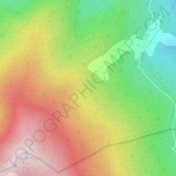
Name: El Poyazo topographic map, elevation, terrain.

Location: El Poyazo, Ortigosa de Cameros, La Rioja, 26125, España (42.13825 -2.70429 42.15825 -2.68429)

Average elevation: 1,443 m

Minimum elevation: 1,141 m

Maximum elevation: 1,758 m

Other topographic maps

Click on a map to view its topography, its elevation and its terrain.

Ortigosa de Cameros

España > La Rioja > Ortigosa de Cameros

En su territorio hubo asentamientos prehistóricos, como lo demuestran las cuevas exploradas de La Paz y de La Viña, donde se encontraron restos de lanzas, sílex y otros útiles prehistóricos. Las cuevas están situadas en el macizo del Encinedo, a 1073 metros de altitud.

Average elevation: 1,298 m

Gear up for your next adventure:

🧤Rechargeable Heated Gloves - Extreme warmth for Canadian winter expeditions
Camping Essentials - All-in-one gear for a comfortable camping trip
🧢Hiking Hat - Sun-protective and breathable hats for long treks
🛌Down Sleeping Bag - Superior warmth-to-weight ratio for cold nights
Bushcraft Tarp - Versatile emergency shelter or gear protection

As an Amazon Associate, this site earns from qualifying purchases at no extra cost to you.