
San Francisco Zapotitlán topographic map
Interactive map
Click on the map to display elevation.
About this map
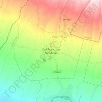
Name: San Francisco Zapotitlán topographic map, elevation, terrain.
Location: San Francisco Zapotitlán, Suchitepéquez, Guatemala (14.54794 -91.56194 14.62794 -91.48194)
Average elevation: 626 m
Minimum elevation: 379 m
Maximum elevation: 980 m
Other topographic maps
Click on a map to view its topography, its elevation and its terrain.
San Francisco Zapotitlán
Guatemala > Suchitepéquez > San Francisco Zapotitlán
San Francisco Zapotitlán, Suchitepéquez, Guatemala
Average elevation: 658 m