Geolocate

Itasca State Park topographic map

Click on the map to display elevation.

About this map

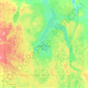
Name: Itasca State Park topographic map, elevation, terrain.

Location: Itasca State Park, Clearwater County, Minnesota, United States (47.13563 -95.29737 47.25020 -95.14141)

Average elevation: 483 m

Minimum elevation: 430 m

Maximum elevation: 558 m

Other topographic maps

Click on a map to view its topography, its elevation and its terrain.

Bagley

United States > Minnesota > Clearwater County

Average elevation: 445 m

Bagley

United States > Minnesota > Clearwater County

Average elevation: 445 m

Clearbrook

United States > Minnesota > Clearwater County

Average elevation: 410 m

Leonard

United States > Minnesota > Clearwater County > Leonard

Average elevation: 440 m

Gear up for your next adventure:

🛶Kayak Accessories - Essential gear for safe and fun kayaking adventures
🧤Rechargeable Heated Gloves - Extreme warmth for Canadian winter expeditions
🧦Crew Hiking Socks - Comfortable socks for long-distance hikes
🧴Insect Repellent - Protect yourself from bugs during outdoor adventures
💡Portable Camping Lamp - Rechargeable lamp for campsite lighting

As an Amazon Associate, this site earns from qualifying purchases at no extra cost to you.