Geolocate

Melur topographic map

Click on the map to display elevation.

About this map

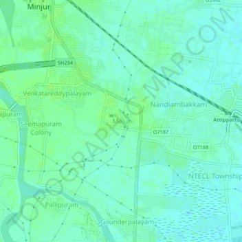
Name: Melur topographic map, elevation, terrain.

Location: Melur, Ponneri, Thiruvallur, Tamil Nadu, 600120, India (13.23950 80.25181 13.27950 80.29181)

Average elevation: 6 m

Minimum elevation: 1 m

Maximum elevation: 10 m

Other topographic maps

Click on a map to view its topography, its elevation and its terrain.

Ponneri Lake

India > Tamil Nadu > Ponneri > Ponneri

Average elevation: 10 m

Kosasthalaiyar River

India > Tamil Nadu > Ponneri > Madiyur

Average elevation: 14 m

Gear up for your next adventure:

🧴Waterproofing Spray - Restore the DWR coating on jackets and tents
🧤Thermal Hiking Gloves - Grip-enhanced gloves for cold-weather altitude trekking
🕯️Camping Lantern - Illuminates your entire campsite with high-efficiency LEDs
🥾Hiking Shorts - Breathable shorts suitable for summer hikes
🧣Merino Neck Gaiter - Protects against wind, sun, and cold at high altitudes

As an Amazon Associate, this site earns from qualifying purchases at no extra cost to you.