
Make a donation
Gear up for your next adventure:
As an Amazon Associate, this site earns from qualifying purchases at no extra cost to you.
Bossier City topographic map
Click on the map to display elevation.
Make a donation
Gear up for your next adventure:
As an Amazon Associate, this site earns from qualifying purchases at no extra cost to you.
Bossier City
Bossier City is located at 32°31′4″N 93°41′29″W / 32.51778°N 93.69139°W / 32.51778; -93.69139 (32.517651, −93.691397) within the Ark-La-Tex and has an elevation of 174 feet (53.0 m) above sea level. The city lies primarily on the banks of the Red River, and has a largely flat topography in contrast with Shreveport's terrain. The northern city limits are noticeably more hilly than the rest of the city. Many small waterways flow through the city, such as Flat River and Red Chute Bayou, which provide drainage for many areas of the city.
Make a donation
Gear up for your next adventure:
As an Amazon Associate, this site earns from qualifying purchases at no extra cost to you.
About this map
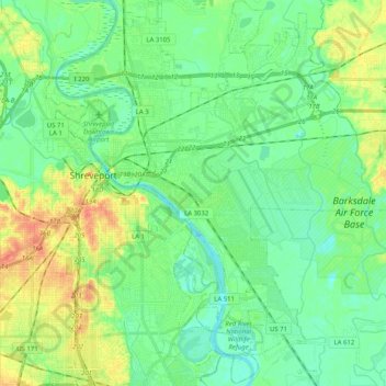
Name: Bossier City topographic map, elevation, terrain.
Location: Bossier City, Bossier Parish, Louisiana, United States (32.41979 -93.74928 32.59081 -93.58433)
Average elevation: 57 m
Minimum elevation: 40 m
Maximum elevation: 86 m
Make a donation
Gear up for your next adventure:
As an Amazon Associate, this site earns from qualifying purchases at no extra cost to you.
Other topographic maps
Click on a map to view its topography, its elevation and its terrain.
Bossier City
United States > Louisiana > Bossier Parish
Bossier City is located at 32°31′4″N 93°41′29″W / 32.51778°N 93.69139°W / 32.51778; -93.69139 (32.517651, −93.691397) within the Ark-La-Tex and has an elevation of 174 feet (53.0 m) above sea level. The city lies primarily on the banks of the Red River, and has a largely flat topography…
Average elevation: 55 m
Make a donation
Gear up for your next adventure:
As an Amazon Associate, this site earns from qualifying purchases at no extra cost to you.
Make a donation
Gear up for your next adventure:
As an Amazon Associate, this site earns from qualifying purchases at no extra cost to you.