Geolocate

Northwest topographic map

Click on the map to display elevation.

About this map

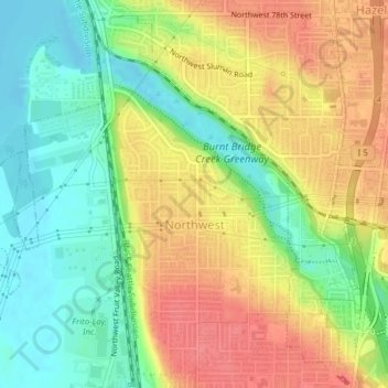
Name: Northwest topographic map, elevation, terrain.

Location: Northwest, Vancouver, Clark County, Washington, United States (45.65354 -122.69319 45.67865 -122.67209)

Average elevation: 36 m

Minimum elevation: -2 m

Maximum elevation: 75 m

Other topographic maps

Click on a map to view its topography, its elevation and its terrain.

Gear up for your next adventure:

🥾Light Trekking Boots - Supportive boots for multi-day treks
🥾Lightweight Hiking Boots - Boots for comfort and mobility on long hikes
🔭Outdoor Binoculars - Lightweight binoculars for birdwatching and hiking
🥾Trail Running Shoes - Lightweight and durable shoes for trail running
🧥Fleece Jacket - Warm and lightweight jacket for layering

As an Amazon Associate, this site earns from qualifying purchases at no extra cost to you.