
Make a donation
Gear up for your next adventure:
As an Amazon Associate, this site earns from qualifying purchases at no extra cost to you.
Sesekinika topographic map
Click on the map to display elevation.
Make a donation
Gear up for your next adventure:
As an Amazon Associate, this site earns from qualifying purchases at no extra cost to you.
About this map
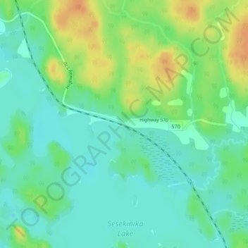
Name: Sesekinika topographic map, elevation, terrain.
Average elevation: 320 m
Minimum elevation: 305 m
Maximum elevation: 356 m
Make a donation
Gear up for your next adventure:
As an Amazon Associate, this site earns from qualifying purchases at no extra cost to you.
Other topographic maps
Click on a map to view its topography, its elevation and its terrain.
Echo Lake
Canada > Ontario > Timiskaming District > Unorganized West Timiskaming
Average elevation: 339 m
Sesekinika Lake
Canada > Ontario > Timiskaming District > Unorganized West Timiskaming
Average elevation: 319 m
Wolf Creek
Canada > Ontario > Timiskaming District > Unorganized West Timiskaming
Average elevation: 327 m