Geolocate

Sini topographic map

Click on the map to display elevation.

About this map

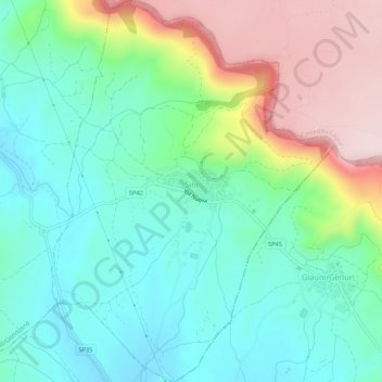
Name: Sini topographic map, elevation, terrain.

Location: Sini, Aristanis/Oristano, Sardinia, 09090, Italy (39.73297 8.88487 39.77380 8.92433)

Average elevation: 294 m

Minimum elevation: 173 m

Maximum elevation: 548 m

Gear up for your next adventure:

🧰Emergency Multi-Tool - Compact multi-tool for outdoor survival
🥾Mountain Hiking Boots - High-traction boots for rocky terrain
🥾Trail Hiking Shoes - Durable shoes designed for rugged trails
🧰Survival Kit - Essential gear for emergencies in the wilderness
👟Sport Hiking Sandals - Breathable footwear for water crossings and camp rest

As an Amazon Associate, this site earns from qualifying purchases at no extra cost to you.