
Carsac topographic map
Interactive map
Click on the map to display elevation.
About this map
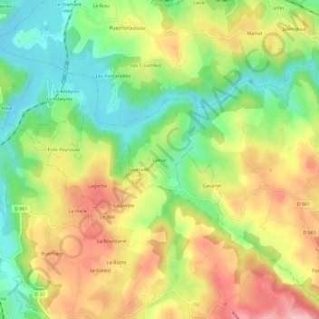
Name: Carsac topographic map, elevation, terrain.
Average elevation: 585 m
Minimum elevation: 504 m
Maximum elevation: 680 m
Other topographic maps
Click on a map to view its topography, its elevation and its terrain.
Le Mieulet
France > Auvergne-Rhône-Alpes > Cantal > Le Rouget-Pers > Pers
Le Mieulet, Pers, Le Rouget-Pers, Aurillac, Cantal, Auvergne-Rhône-Alpes, France métropolitaine, 15290, France
Average elevation: 552 m
Les Troix Croix
France > Auvergne-Rhône-Alpes > Cantal > Le Rouget-Pers > Pers
Les Troix Croix, Pers, Le Rouget-Pers, Aurillac, Cantal, Auvergne-Rhône-Alpes, France métropolitaine, 15290, France
Average elevation: 595 m
Selves
France > Auvergne-Rhône-Alpes > Cantal > Le Rouget-Pers > Pers
Selves, Pers, Le Rouget-Pers, Aurillac, Cantal, Auvergne-Rhône-Alpes, France métropolitaine, 15290, France
Average elevation: 573 m