Geolocate

anuli topographic map

Click on the map to display elevation.

About this map

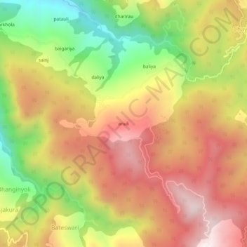
Name: anuli topographic map, elevation, terrain.

Location: anuli, Lamgara Tehsil, Almora, Uttarakhand, 263625, India (29.48080 79.71463 29.52080 79.75463)

Average elevation: 1,776 m

Minimum elevation: 1,320 m

Maximum elevation: 2,154 m

Gear up for your next adventure:

Tent Footprint - Protect tent floor and increase durability
🧭Orienteering Kit - Tools for map reading and navigation in the wild
🧢Hiking Hat - Sun-protective and breathable hats for long treks
🔨Vehicle Emergency Tool - Safety tool for remote road trips to trailheads
🥾Approach Boots - Comfortable boots for hiking and climbing approaches

As an Amazon Associate, this site earns from qualifying purchases at no extra cost to you.