Geolocate

Palmerston topographic map

Click on the map to display elevation.

About this map

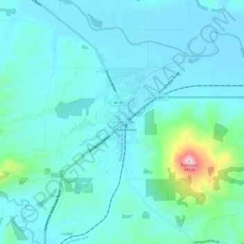
Name: Palmerston topographic map, elevation, terrain.

Location: Palmerston, Waitaki District, Otago, 9430, New Zealand (-45.50424 170.69532 -45.46424 170.73532)

Average elevation: 51 m

Minimum elevation: 6 m

Maximum elevation: 317 m

Other topographic maps

Click on a map to view its topography, its elevation and its terrain.

Kakanui Mountains

New Zealand > Otago > Waitaki District

Average elevation: 784 m

Kakanui River

New Zealand > Otago > Waitaki District

Average elevation: 315 m

Pleasant River

New Zealand > Otago > Waitaki District

Average elevation: 108 m

Gear up for your next adventure:

🥾Approach Shoes - Shoes designed for climbing approaches and rugged trails
🧢Beanie Hat - Keep your head warm in cold weather
🔦LED Headlamp - Hands-free lighting for early morning starts or late finishes
🥾Waterproof Hiking Boots - Boots keeping your feet dry in wet conditions
🥾Trail Hiking Socks - Comfortable socks to prevent blisters and fatigue

As an Amazon Associate, this site earns from qualifying purchases at no extra cost to you.