
Make a donation
Gear up for your next adventure:
As an Amazon Associate, this site earns from qualifying purchases at no extra cost to you.
Harmony Flat topographic map
Click on the map to display elevation.
Make a donation
Gear up for your next adventure:
As an Amazon Associate, this site earns from qualifying purchases at no extra cost to you.
About this map
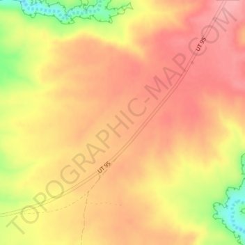
Name: Harmony Flat topographic map, elevation, terrain.
Location: Harmony Flat, San Juan County, Utah, United States (37.54112 -109.95243 37.56112 -109.93243)
Average elevation: 2,024 m
Minimum elevation: 1,948 m
Maximum elevation: 2,060 m
Make a donation
Gear up for your next adventure:
As an Amazon Associate, this site earns from qualifying purchases at no extra cost to you.
Other topographic maps
Click on a map to view its topography, its elevation and its terrain.
Natural Bridges National Monument
United States > Utah > San Juan County
Located within the Colorado Plateau, the monument has three distinct bridges in White and Armstrong Canyons. These canyons were formed when the Colorado River eroded the Permian Cedar Mesa Sandstone. The Sipapu, Kachina, and Owachoma bridges were formed through rock decay, weathering and erosion, as water cut…
Average elevation: 1,916 m
Make a donation
Gear up for your next adventure:
As an Amazon Associate, this site earns from qualifying purchases at no extra cost to you.
Make a donation
Gear up for your next adventure:
As an Amazon Associate, this site earns from qualifying purchases at no extra cost to you.
Make a donation
Gear up for your next adventure:
As an Amazon Associate, this site earns from qualifying purchases at no extra cost to you.
Make a donation
Gear up for your next adventure:
As an Amazon Associate, this site earns from qualifying purchases at no extra cost to you.
Monticello
United States > Utah > San Juan County
Monticello is located at the base of the Abajo Mountains, or the Blue Mountains, which are part of the Manti-La Sal National Forest. The elevation of Monticello is 7,069 feet (2,155 m). From Monticello, a tree formation on the Blue Mountains can be seen, which resembles a horse's head and neck, which can be…
Average elevation: 2,145 m
Make a donation
Gear up for your next adventure:
As an Amazon Associate, this site earns from qualifying purchases at no extra cost to you.