Geolocate

Mechanicsburg topographic map

Click on the map to display elevation.

About this map

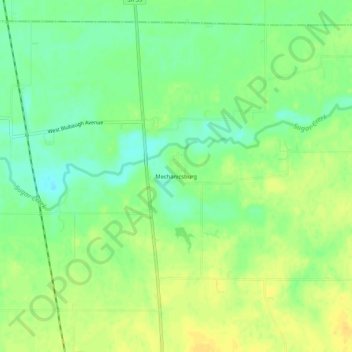
Name: Mechanicsburg topographic map, elevation, terrain.

Location: Mechanicsburg, Boone County, Indiana, United States (40.13976 -86.50111 40.17976 -86.46111)

Average elevation: 272 m

Minimum elevation: 258 m

Maximum elevation: 283 m

Other topographic maps

Click on a map to view its topography, its elevation and its terrain.

Zionsville

United States > Indiana > Boone County

Average elevation: 273 m

Whitestown

United States > Indiana > Boone County

Average elevation: 286 m

Lebanon

United States > Indiana > Boone County

Average elevation: 287 m

Whitestown

United States > Indiana > Boone County

Average elevation: 286 m

Zionsville

United States > Indiana > Boone County

Average elevation: 273 m

Gear up for your next adventure:

💡Portable Camping Lamp - Rechargeable lamp for campsite lighting
🧥Insulated Jacket - Keep warm in cold outdoor conditions
🧢Sun Hat - Wide-brim hat for sun protection
💡LED Headlamp - Hands-free illumination for night hiking and camping
🥾Hiking Shoes - Durable and comfortable shoes for trail hiking

As an Amazon Associate, this site earns from qualifying purchases at no extra cost to you.