Geolocate

Eleanor topographic map

Click on the map to display elevation.

About this map

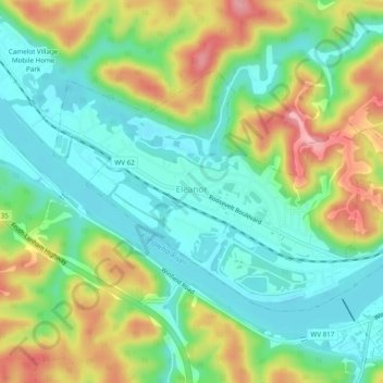
Name: Eleanor topographic map, elevation, terrain.

Location: Eleanor, Putnam County, West Virginia, 25070, United States (38.52552 -81.94987 38.54924 -81.90154)

Average elevation: 213 m

Minimum elevation: 165 m

Maximum elevation: 296 m

Other topographic maps

Click on a map to view its topography, its elevation and its terrain.

Liberty

United States > West Virginia > Putnam County

Average elevation: 281 m

Gear up for your next adventure:

🦶Hiking Shoe Insoles - Added support for high arches and long days on feet
💡Solar Camping Lamp - Eco-friendly lighting for campsites
🥾Trekking Boots - Durable boots for long-distance trekking
🔭Compact Monocular - One-handed bird watching and trail spotting
🧤Rechargeable Heated Gloves - Extreme warmth for Canadian winter expeditions

As an Amazon Associate, this site earns from qualifying purchases at no extra cost to you.