
Make a donation
Gear up for your next adventure:
As an Amazon Associate, this site earns from qualifying purchases at no extra cost to you.
Lochmaddy topographic map
Click on the map to display elevation.
Make a donation
Gear up for your next adventure:
As an Amazon Associate, this site earns from qualifying purchases at no extra cost to you.
About this map
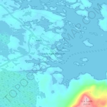
Name: Lochmaddy topographic map, elevation, terrain.
Location: Lochmaddy, Western Isles, Scotland, HS6 5AA, United Kingdom (57.57963 -7.18086 57.61963 -7.14086)
Average elevation: 16 m
Minimum elevation: -8 m
Maximum elevation: 247 m
Make a donation
Gear up for your next adventure:
As an Amazon Associate, this site earns from qualifying purchases at no extra cost to you.
Other topographic maps
Click on a map to view its topography, its elevation and its terrain.
Àird
United Kingdom > Scotland > Western Isles
There is a dense cluster of lochs across almost the entire island, and almost all of the island is below 20 metres (70 feet) in elevation.
Average elevation: 5 m