
Thank you for supporting this site ❤️
Make a donation
Make a donation
Gear up for your next adventure:
As an Amazon Associate, this site earns from qualifying purchases at no extra cost to you.
Tor San Lorenzo topographic map
Click on the map to display elevation.
Thank you for supporting this site ❤️
Make a donation
Make a donation
Gear up for your next adventure:
As an Amazon Associate, this site earns from qualifying purchases at no extra cost to you.
Tor San Lorenzo
(Papa Gregorio VII, da Antonio Nibby, Analisi storico-topografico-archeologica della carta de' dintorni di Roma.)
Thank you for supporting this site ❤️
Make a donation
Make a donation
Gear up for your next adventure:
As an Amazon Associate, this site earns from qualifying purchases at no extra cost to you.
About this map
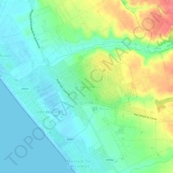
Name: Tor San Lorenzo topographic map, elevation, terrain.
Location: Tor San Lorenzo, Ardea, Roma, Lazio, 00040, Italia (41.54958 12.52079 41.58958 12.56079)
Average elevation: 21 m
Minimum elevation: -1 m
Maximum elevation: 65 m
Thank you for supporting this site ❤️
Make a donation
Make a donation
Gear up for your next adventure:
As an Amazon Associate, this site earns from qualifying purchases at no extra cost to you.