
Arentim e Cunha topographic map
Interactive map
Click on the map to display elevation.
About this map
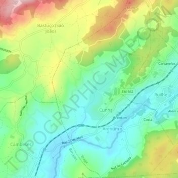
Name: Arentim e Cunha topographic map, elevation, terrain.
Location: Arentim e Cunha, Braga, Portugal (41.47769 -8.52609 41.51144 -8.49507)
Average elevation: 172 m
Minimum elevation: 83 m
Maximum elevation: 336 m
Other topographic maps
Click on a map to view its topography, its elevation and its terrain.