
Make a donation
Gear up for your next adventure:
As an Amazon Associate, this site earns from qualifying purchases at no extra cost to you.
Illimani topographic map
Click on the map to display elevation.
Make a donation
Gear up for your next adventure:
As an Amazon Associate, this site earns from qualifying purchases at no extra cost to you.
Illimani
El Illimani es un enorme macizo de más de 8 km de longitud y cuatro cumbres que sobrepasan los 6.000 de altitud, estas discurren de noroeste a sureste, y de ellas es el último nevado de la Cordillera Real de norte a sur; por el norte el cordón comienza con el Nevado Illampu y termina por el sur con el Illimani (suroeste).
Make a donation
Gear up for your next adventure:
As an Amazon Associate, this site earns from qualifying purchases at no extra cost to you.
About this map
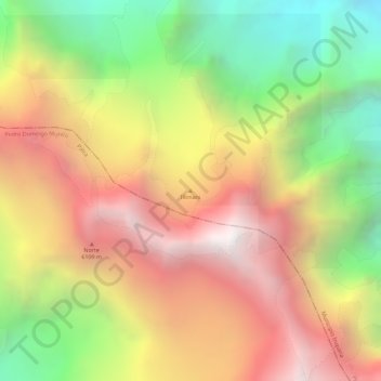
Name: Illimani topographic map, elevation, terrain.
Average elevation: 5,672 m
Minimum elevation: 4,856 m
Maximum elevation: 6,356 m
Make a donation
Gear up for your next adventure:
As an Amazon Associate, this site earns from qualifying purchases at no extra cost to you.
Other topographic maps
Click on a map to view its topography, its elevation and its terrain.
Cooperativa Minera Bolsa Negra
Bolivia > La Paz > Provincia Sud Yungas > Municipio Irupana
Average elevation: 4,255 m