Geolocate

Labangon topographic map

Click on the map to display elevation.

About this map

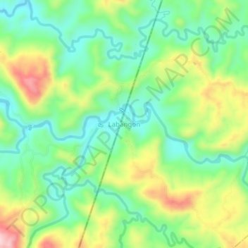
Name: Labangon topographic map, elevation, terrain.

Location: Labangon, Zamboanga del Sur, Zamboanga Peninsula, Philippines (8.10606 123.16616 8.14606 123.20616)

Average elevation: 194 m

Minimum elevation: 92 m

Maximum elevation: 372 m

Other topographic maps

Click on a map to view its topography, its elevation and its terrain.

Sominot

Philippines > Zamboanga del Sur

Average elevation: 261 m

Midsalip

Philippines > Zamboanga del Sur

Average elevation: 363 m

Midsalip

Philippines > Zamboanga del Sur

Average elevation: 363 m

Gear up for your next adventure:

🕯️Camping Lantern - Illuminates your entire campsite with high-efficiency LEDs
🥾Hiking Gaiters - Protect legs and shoes from mud, snow, and debris
🥾Trail Running Shoes - Lightweight and durable shoes for trail running
💡Portable Camping Lamp - Rechargeable lamp for campsite lighting
💧Filtered Water Bottle - Safe drinking water on the go

As an Amazon Associate, this site earns from qualifying purchases at no extra cost to you.