
Make a donation
Gear up for your next adventure:
As an Amazon Associate, this site earns from qualifying purchases at no extra cost to you.
Praia do Norte topographic map
Click on the map to display elevation.
Make a donation
Gear up for your next adventure:
As an Amazon Associate, this site earns from qualifying purchases at no extra cost to you.
About this map
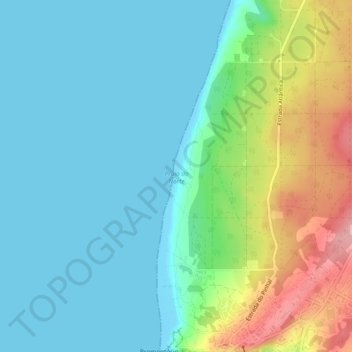
Name: Praia do Norte topographic map, elevation, terrain.
Location: Praia do Norte, Nazaré, Leiria, Portugal (39.60469 -9.08607 39.64116 -9.07479)
Average elevation: 36 m
Minimum elevation: -1 m
Maximum elevation: 138 m
Make a donation
Gear up for your next adventure:
As an Amazon Associate, this site earns from qualifying purchases at no extra cost to you.
Other topographic maps
Click on a map to view its topography, its elevation and its terrain.
Sítio Classificado do Monte de São Bartolomeu
O Monte de São Bartolomeu, próximo da vila da Nazaré, é uma elevação de origem magmática. O cume, aos 156m, é acessível por um caminho a nascente, e por uma escadaria a poente, mais moderna.
Average elevation: 48 m
Make a donation
Gear up for your next adventure:
As an Amazon Associate, this site earns from qualifying purchases at no extra cost to you.