Geolocate

Tolima topographic map

Click on the map to display elevation.

About this map

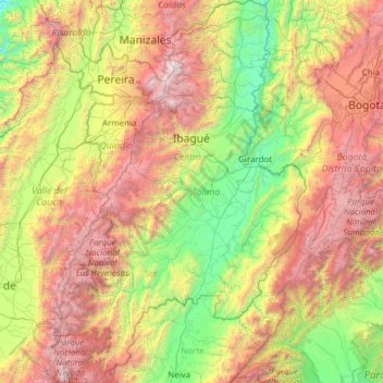
Name: Tolima topographic map, elevation, terrain.

Location: Tolima, RAP (Especial) Central, Colombia (2.87050 -76.10643 5.31946 -74.47468)

Average elevation: 1,687 m

Minimum elevation: 129 m

Maximum elevation: 5,262 m

Other topographic maps

Click on a map to view its topography, its elevation and its terrain.

Chicamocha

Colombia > Santander > Jordán

Average elevation: 641 m

Quinchana

Colombia > Huila > San Agustín

Average elevation: 2,082 m

Sincelejo

Colombia > Sucre > Sincelejo

The geography of Sincelejo is characterized by a hilly landscape which extends from the mountains to the borders of the plateau in the north and south. The small mountain foothills in the municipality span from the marine fluvial plain in the west to the border shared with the town of Palmito. Erosion is…

Average elevation: 121 m

Las Lajas

Colombia > Nariño > Ipiales

Average elevation: 2,789 m

Vaupés

Colombia

Average elevation: 163 m

Barrancabermeja

Colombia > Santander > Barrancabermeja

Average elevation: 82 m

Puerto Limon

Colombia > Santander > Sabana de Torres

Average elevation: 87 m

Guaviare

Colombia

Average elevation: 345 m

Santa Marta

Colombia > Magdalena > Santa Marta

Average elevation: 193 m

Gear up for your next adventure:

🥾Mountain Hiking Boots - High-traction boots for rocky terrain
🩹Moleskin Blister Pads - Direct protection for painful foot pressure points
🦶Anti-Blister Balm - Prevents friction and hotspots during long ascents
👟Trail Running Shoes - Agile footwear for fast-paced topographic exploration
🧢Sun Protection Cap - Breathable cap to protect from sun exposure

As an Amazon Associate, this site earns from qualifying purchases at no extra cost to you.