Geolocate

Picinisco topographic map

Click on the map to display elevation.

About this map

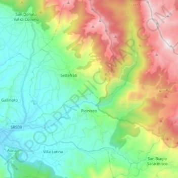
Name: Picinisco topographic map, elevation, terrain.

Location: Picinisco, Frosinone, Lazio, Italy (41.60223 13.82594 41.71901 13.97457)

Average elevation: 968 m

Minimum elevation: 345 m

Maximum elevation: 2,228 m

Other topographic maps

Click on a map to view its topography, its elevation and its terrain.

Monte Sammucro

Italy > Lazio > Frosinone > San Vittore del Lazio

Average elevation: 691 m

San Silvestro

Italy > Lazio > Frosinone > Cassino

Average elevation: 163 m

Cartiera-Stazione

Italy > Lazio > Frosinone > Ferentino

Average elevation: 171 m

Colle San Giacomo

Italy > Lazio > Frosinone > Veroli

Average elevation: 816 m

Gear up for your next adventure:

🥾Trail Hiking Boots - Supportive boots for rough trails
🧢Sun Hat - Wide-brim hat for sun protection
👟Sport Hiking Sandals - Breathable footwear for water crossings and camp rest
🧭GPS Tracker - Track your location in remote areas safely
❄️Traction Ice Cleats - Slip-on spikes for icy trails and winter hiking

As an Amazon Associate, this site earns from qualifying purchases at no extra cost to you.