Geolocate

Macael topographic map

Click on the map to display elevation.

About this map

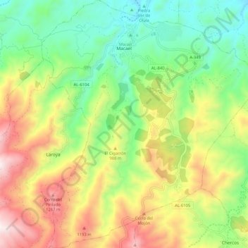
Name: Macael topographic map, elevation, terrain.

Location: Macael, Valle del Almanzora, Almeria, Andalusia, 04867, Spain (37.26489 -2.33683 37.34685 -2.24314)

Average elevation: 839 m

Minimum elevation: 455 m

Maximum elevation: 1,407 m

Gear up for your next adventure:

🧊Insulated Water Bottle - Keeps drinks cold in summer and prevents freezing in winter
🧦Merino Wool Socks - Moisture-wicking comfort for long-distance hiking
🥾Light Trekking Boots - Supportive boots for multi-day treks
Camping Essentials - All-in-one gear for a comfortable camping trip
🧢Beanie Hat - Keep your head warm in cold weather

As an Amazon Associate, this site earns from qualifying purchases at no extra cost to you.