Geolocate

Val Salice topographic map

Click on the map to display elevation.

About this map

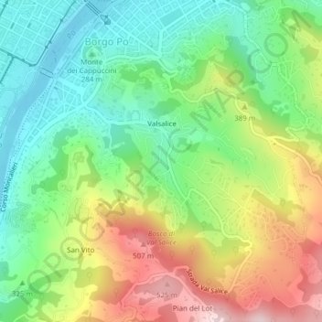
Name: Val Salice topographic map, elevation, terrain.

Location: Val Salice, Circoscrizione 8, Turin, Torino, Piedmont, Italy (45.04359 7.69318 45.05764 7.71719)

Average elevation: 340 m

Minimum elevation: 216 m

Maximum elevation: 536 m

Other topographic maps

Click on a map to view its topography, its elevation and its terrain.

Fioccardo

Italy > Piedmont > Torino > Turin > Cavoretto

Average elevation: 281 m

Gear up for your next adventure:

🔋Emergency Crank Radio - Weather alerts and power without needing batteries
💧Hydration Bladder - Hands-free hydration solution for long treks
🚑Survival Whistle - Signal for help across long distances in mountains
🧴Bear Spray Holster - Quick-access carry for essential Canadian wilderness safety
Tent Footprint - Protect tent floor and increase durability

As an Amazon Associate, this site earns from qualifying purchases at no extra cost to you.