
Balatonfüredi járás topographic map
Interactive map
Click on the map to display elevation.
About this map
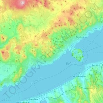
Name: Balatonfüredi járás topographic map, elevation, terrain.
Average elevation: 206 m
Minimum elevation: 99 m
Maximum elevation: 596 m
Other topographic maps
Click on a map to view its topography, its elevation and its terrain.
Lac
Hongrie > Veszprém vármegye > Tés
Lac, Tés, Várpalotai járás, Veszprém vármegye, Transdanubie centrale, Transdanubie, 8109, Hongrie
Average elevation: 408 m
Csopak
Csopak, Balatonfüredi járás, Veszprém vármegye, Transdanubie centrale, Transdanubie, 8229, Hongrie
Average elevation: 158 m
Veszprém
Veszprém, Veszprémi járás, Veszprém vármegye, Transdanubie centrale, Transdanubie, Hongrie
Average elevation: 292 m