Geolocate

Salang topographic map

Click on the map to display elevation.

About this map

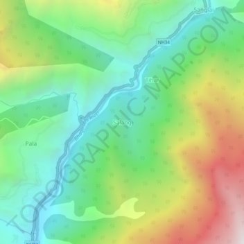
Name: Salang topographic map, elevation, terrain.

Location: Salang, Bhatwari, Uttarkashi District, Uttarakhand, India (30.82213 78.61557 30.86213 78.65557)

Average elevation: 2,172 m

Minimum elevation: 1,579 m

Maximum elevation: 3,283 m

Other topographic maps

Click on a map to view its topography, its elevation and its terrain.

Kyarkoti Lake

India > Uttarakhand > Bhatwari

Average elevation: 4,043 m

Harsil

India > Uttarakhand > Bhatwari

Average elevation: 2,761 m

Pari Maatri Taal

India > Uttarakhand > Bhatwari

Average elevation: 4,443 m

Kedar Tal

India > Uttarakhand > Bhatwari

Average elevation: 4,814 m

Harsil

India > Uttarakhand > Bhatwari

Average elevation: 2,761 m

Dayara Bugyal

India > Uttarakhand > Bhatwari

Average elevation: 3,451 m

Kalindi Khal Area

India > Uttarakhand > Bhatwari

Average elevation: 5,857 m

Gangotri Glacier

India > Uttarakhand > Bhatwari

Average elevation: 5,259 m

Kedar Tal

India > Uttarakhand > Bhatwari

Average elevation: 4,814 m

Gangotri Glacier

India > Uttarakhand > Bhatwari

Average elevation: 5,259 m

Gear up for your next adventure:

🛶Kayak Accessories - Essential gear for safe and fun kayaking adventures
🧢Outdoor Visor - Breathable visor for sunny hikes
🎒Hiking Daypack - Lightweight and durable backpacks for day trips and excursions
🥾Mountaineering Boots - Supportive boots for climbing and high-altitude hiking
🧢Sun Hat - Wide-brim hat for sun protection

As an Amazon Associate, this site earns from qualifying purchases at no extra cost to you.