
Nachá topographic map
Click on the map to display elevation.
About this map
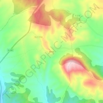
Name: Nachá topographic map, elevation, terrain.
Location: Nachá, Baells, La Litera, Huesca, Aragón, España (41.93649 0.47204 41.97649 0.51204)
Average elevation: 681 m
Minimum elevation: 547 m
Maximum elevation: 858 m
Other topographic maps
Click on a map to view its topography, its elevation and its terrain.
Tamarite de Litera / Tamarit de Llitera
La población se encuentra situada al este de la capital y al norte de la comunidad autónoma. Se encuentra una altitud de 360 m sobre el nivel del mar y carece de accidentes fluviales más allá de las torrenteras y cauces subterráneos originados en las zonas más elevadas de la comarca.
Average elevation: 278 m