Geolocate

Eldean topographic map

Click on the map to display elevation.

About this map

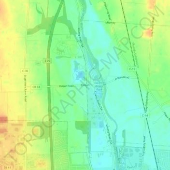
Name: Eldean topographic map, elevation, terrain.

Location: Eldean, Miami County, Ohio, 45373, United States (40.05783 -84.24244 40.09783 -84.20244)

Average elevation: 266 m

Minimum elevation: 249 m

Maximum elevation: 288 m

Other topographic maps

Click on a map to view its topography, its elevation and its terrain.

Laura

United States > Ohio > Miami County

Average elevation: 303 m

Bethal Park

United States > Ohio > Miami County

Average elevation: 287 m

Bradford

United States > Ohio > Miami County

Average elevation: 302 m

Casstown

United States > Ohio > Miami County

Average elevation: 284 m

Fletcher

United States > Ohio > Miami County

Average elevation: 320 m

Pleasant Hill

United States > Ohio > Miami County

Average elevation: 277 m

West Milton

United States > Ohio > Miami County

Average elevation: 284 m

Brukner Park

United States > Ohio > Miami County > Troy

Average elevation: 256 m

Gear up for your next adventure:

🧊Portable Cooler - Keep food and drinks cold during outdoor adventures
🎒Fully Waterproof Backpack - Total protection for photography gear and electronics
🥾Lightweight Hiking Boots - Boots for comfort and mobility on long hikes
🧤Thermal Hiking Gloves - Grip-enhanced gloves for cold-weather altitude trekking
🧳Compression Sacks - Maximize space in your backpack by shrinking gear

As an Amazon Associate, this site earns from qualifying purchases at no extra cost to you.