Geolocate

Schneverdingen topographic map

Click on the map to display elevation.

About this map

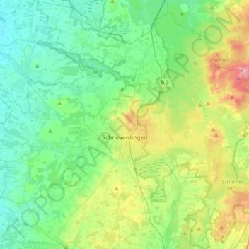
Name: Schneverdingen topographic map, elevation, terrain.

Location: Schneverdingen, Heidekreis, Lower Saxony, 29640, Germany (53.03223 9.62528 53.21947 9.93772)

Average elevation: 71 m

Minimum elevation: 36 m

Maximum elevation: 168 m

Other topographic maps

Click on a map to view its topography, its elevation and its terrain.

Wilsede

Germany > Lower Saxony > Heidekreis

Average elevation: 114 m

Lüneburg Heath

Germany > Lower Saxony > Heidekreis > Soltau > Hötzingen > Emhof

Average elevation: 85 m

Gear up for your next adventure:

🧰Survival Kit - Essential gear for emergencies in the wilderness
🥾Trail Hiking Shoes - Durable shoes designed for rugged trails
🩹Moleskin Blister Pads - Direct protection for painful foot pressure points
🌬️Windproof Camp Stove - Efficient cooking even on exposed mountain peaks
🧦Crew Hiking Socks - Comfortable socks for long-distance hikes

As an Amazon Associate, this site earns from qualifying purchases at no extra cost to you.