Geolocate

Rapolla topographic map

Click on the map to display elevation.

About this map

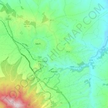
Name: Rapolla topographic map, elevation, terrain.

Location: Rapolla, Potenza, Basilicata, 85027, Italy (40.95489 15.64315 41.02193 15.74862)

Average elevation: 513 m

Minimum elevation: 217 m

Maximum elevation: 1,300 m

Other topographic maps

Click on a map to view its topography, its elevation and its terrain.

Viadotto Pantanelle

Italy > Basilicata > Potenza > Nemoli

Average elevation: 1,685 m

Porco Morto

Italy > Basilicata > Potenza > Picerno > Porco Morto

Average elevation: 1,071 m

Gear up for your next adventure:

🥽Outdoor Goggles - Protective eyewear for outdoor activities
🥾All-Terrain Hiking Boots - Versatile boots for varied hiking conditions
🔭Compact Monocular - One-handed bird watching and trail spotting
🧢Sun Hat - Wide-brim hat for sun protection
🧦Merino Wool Socks - Moisture-wicking comfort for long-distance hiking

As an Amazon Associate, this site earns from qualifying purchases at no extra cost to you.