Geolocate

Sengal topographic map

Click on the map to display elevation.

About this map

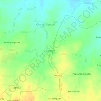
Name: Sengal topographic map, elevation, terrain.

Location: Sengal, Krishnarayapuram, Karur, Tamil Nadu, 639102, India (10.84851 78.22925 10.88851 78.26925)

Average elevation: 134 m

Minimum elevation: 120 m

Maximum elevation: 150 m

Gear up for your next adventure:

Camping Tent - Weather-resistant tents suitable for 2 to 6 people
🧢Outdoor Cap - Protective cap for sun and rain during hikes
🧥Waterproof Jacket - Lightweight rain jackets for hiking and outdoor activities
💧Filtered Water Bottle - Safe drinking water on the go
🛶Canoe Life Vest - Safety vest for water sports

As an Amazon Associate, this site earns from qualifying purchases at no extra cost to you.