
Worcester topographic map
Click on the map to display elevation.
Worcester
Worcester is known for being particularly snowy in the cold months, sometimes even experiencing intense autumn blizzards. The city averages 48.07 inches (1,220 mm) of precipitation a year, as well as an average of 64 inches (160 cm) of snowfall a season, receiving far more snow than coastal locations less than 40 miles (64 km) away. Massachusetts' geographic location, jutting out into the North Atlantic, as well as Worcester's elevation relative to the surrounding terrain, makes the city very prone to Nor'easter weather systems that can dump heavy snow on the region. Extreme winters have brought up to 120 inches (300 cm) of snowfall, as happened in 2005. In late January 2015, a blizzard traversed over the city as it shed almost 32 inches (81 cm) of snow. This was the highest single-day snowfall total for anywhere in Massachusetts since data collection began in 1892.
About this map
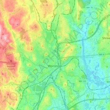
Name: Worcester topographic map, elevation, terrain.
Location: Worcester, Worcester County, Massachusetts, United States (42.21004 -71.88404 42.34119 -71.73124)
Average elevation: 186 m
Minimum elevation: 104 m
Maximum elevation: 363 m
Other topographic maps
Click on a map to view its topography, its elevation and its terrain.
South Barre
United States > Massachusetts > Worcester County > Barre > South Barre
Average elevation: 223 m