Geolocate

Vitória topographic map

Click on the map to display elevation.

Vitória

The relief of the islands is an extension of the continent, whether granite, surrounded by the sea and native Brazilian restinga-mangue vegetation. The central massif of the island of Vitória, Morro da Fonte Grande, has an altitude of 308.8 m and the main granitic outcrops are Pedra dos Dois Olhos, with 296m, and Morro de São Benedito, with 194m of altitude. Vitória's highest point is Pico do Desejado, located in the Trindade Island, with 601m of altitude, eleven hundred kilometers away from the mainland coastline.

Wikipedia (CC-BY-SA 3.0)

About this map

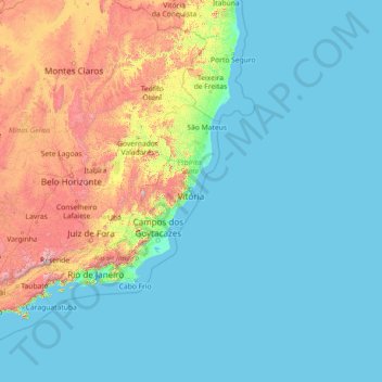
Name: Vitória topographic map, elevation, terrain.

Location: Vitória, Região Geográfica Imediata de Vitória, Greater Vitória, Região Geográfica Intermediária de Vitória, Espírito Santo, Southeast Region, Brazil (-20.52826 -40.36233 -20.22916 -28.84764)

Average elevation: 250 m

Minimum elevation: -1 m

Maximum elevation: 2,555 m

Gear up for your next adventure:

Lightweight Backpacking Tent - Compact tent for efficient hiking trips
🦟Insect Repellent - Keep mosquitoes and black flies away in wooded areas
🥾Trekking Poles - Adjustable trekking poles to reduce knee stress and improve stability
Lightweight Camping Tent - Portable shelter optimized for Canadian backcountry camping
🥾Hiking Boots - Sturdy boots providing ankle support and traction on rugged trails

As an Amazon Associate, this site earns from qualifying purchases at no extra cost to you.