
Thank you for supporting this site ❤️
Make a donation
Make a donation
Gear up for your next adventure:
As an Amazon Associate, this site earns from qualifying purchases at no extra cost to you.
Schwarzenberg topographic map
Click on the map to display elevation.
Thank you for supporting this site ❤️
Make a donation
Make a donation
Gear up for your next adventure:
As an Amazon Associate, this site earns from qualifying purchases at no extra cost to you.
About this map
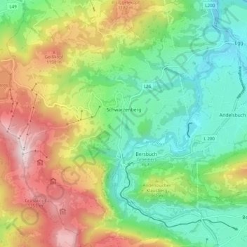
Name: Schwarzenberg topographic map, elevation, terrain.
Location: Schwarzenberg, Bezirk Bregenz, Vorarlberg, 6867, Austria (47.37730 9.80117 47.44267 9.88199)
Average elevation: 868 m
Minimum elevation: 518 m
Maximum elevation: 1,452 m
Thank you for supporting this site ❤️
Make a donation
Make a donation
Gear up for your next adventure:
As an Amazon Associate, this site earns from qualifying purchases at no extra cost to you.