
Abulug River topographic map
Click on the map to display elevation.
About this map
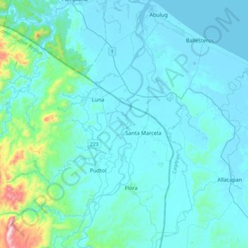
Name: Abulug River topographic map, elevation, terrain.
Location: Abulug River, Apayao, Cagayan Valley, Philippines (18.13582 121.34441 18.46254 121.44636)
Average elevation: 77 m
Minimum elevation: -3 m
Maximum elevation: 864 m
Other topographic maps
Click on a map to view its topography, its elevation and its terrain.
Calanasan
The town's topography or slope is predominantly rugged and mountainous with sporadic flood plains and plateaus. The municipality cradles the larger part of the Apayao-Abulog watershed area as the main source of streams that fills the mighty river which originates from the municipality.
Average elevation: 524 m