Geolocate

Winzer topographic map

Click on the map to display elevation.

About this map

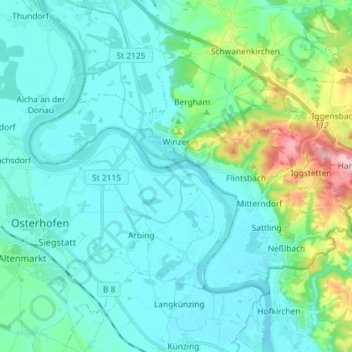
Name: Winzer topographic map, elevation, terrain.

Location: Winzer, Landkreis Deggendorf, Bavaria, 94577, Germany (48.68243 13.01578 48.74682 13.16016)

Average elevation: 332 m

Minimum elevation: 302 m

Maximum elevation: 476 m

Other topographic maps

Click on a map to view its topography, its elevation and its terrain.

Kapfing

Germany > Bavaria > Landkreis Deggendorf

Average elevation: 484 m

Gear up for your next adventure:

🎒Fully Waterproof Backpack - Total protection for photography gear and electronics
🛶Kayak Accessories - Essential gear for safe and fun kayaking adventures
🥾Trekking Poles - Adjustable trekking poles to reduce knee stress and improve stability
🧭Orienteering Kit - Tools for map reading and navigation in the wild
🥾Lightweight Hiking Boots - Boots for comfort and mobility on long hikes

As an Amazon Associate, this site earns from qualifying purchases at no extra cost to you.