Geolocate

Angwin topographic map

Click on the map to display elevation.

About this map

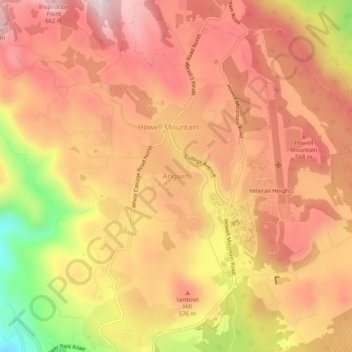
Name: Angwin topographic map, elevation, terrain.

Location: Angwin, Napa County, California, 94508, United States (38.55574 -122.46998 38.59574 -122.42998)

Average elevation: 517 m

Minimum elevation: 235 m

Maximum elevation: 669 m

Other topographic maps

Click on a map to view its topography, its elevation and its terrain.

Napa

United States > California > Napa County

Average elevation: 86 m

Napa

United States > California > Napa County

Average elevation: 86 m

Angwin

United States > California > Napa County > Angwin

Average elevation: 500 m

Napa Valley AVA

United States > California > Napa County

Napa Valley's climate and geography are shaped by a unique cooling effect, crucial for premium grape growing. Originating from a cold ocean current from Alaska, this effect involves fog formation and cool air influx from the Pacific, offset by warmer air rising from California's Central Valley. This dynamic…

Average elevation: 222 m

Deer Park

United States > California > Napa County > Sanitarium

Average elevation: 189 m

Yountville

United States > California > Napa County

Average elevation: 68 m

Calistoga

United States > California > Napa County

Average elevation: 162 m

St. Helena

United States > California > Napa County

Average elevation: 111 m

St. Helena

United States > California > Napa County

Average elevation: 174 m

Napa Valley AVA

United States > California > Napa County

Napa Valley's climate and geography are shaped by a unique cooling effect, crucial for premium grape growing. Originating from a cold ocean current from Alaska, this effect involves fog formation and cool air influx from the Pacific, offset by warmer air rising from California's Central Valley. This dynamic…

Average elevation: 222 m

Lake Berryessa

United States > California > Napa County

Average elevation: 322 m

Yountville

United States > California > Napa County

Average elevation: 59 m

Napa

United States > California > Napa County

Average elevation: 86 m

Gear up for your next adventure:

🧦Crew Hiking Socks - Comfortable socks for long-distance hikes
🔥Emergency Fire Starter - Reliable ignition source for all weather conditions
🪑Insulated Seat Pad - Protect your seat from cold rocks and wet logs
🧢Sun Hat - Wide-brim hat for sun protection
🧣Merino Neck Gaiter - Protects against wind, sun, and cold at high altitudes

As an Amazon Associate, this site earns from qualifying purchases at no extra cost to you.