
Make a donation
Gear up for your next adventure:
As an Amazon Associate, this site earns from qualifying purchases at no extra cost to you.
Durban topographic map
Click on the map to display elevation.
Make a donation
Gear up for your next adventure:
As an Amazon Associate, this site earns from qualifying purchases at no extra cost to you.
About this map
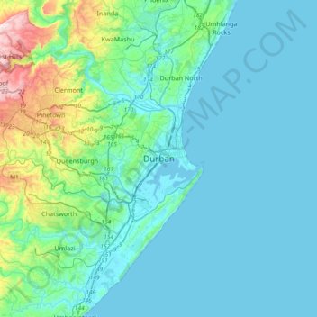
Name: Durban topographic map, elevation, terrain.
Average elevation: 83 m
Minimum elevation: -1 m
Maximum elevation: 600 m
Make a donation
Gear up for your next adventure:
As an Amazon Associate, this site earns from qualifying purchases at no extra cost to you.
Other topographic maps
Click on a map to view its topography, its elevation and its terrain.
Inanda Dam
South Africa > KwaZulu-Natal > eThekwini Metropolitan Municipality
Average elevation: 222 m
Umhlanga River
South Africa > KwaZulu-Natal > eThekwini Metropolitan Municipality > Phoenix
Average elevation: 130 m
Umgeni River
South Africa > KwaZulu-Natal > eThekwini Metropolitan Municipality > Queensburgh
Average elevation: 131 m
Make a donation
Gear up for your next adventure:
As an Amazon Associate, this site earns from qualifying purchases at no extra cost to you.
Pigeon Valley
South Africa > KwaZulu-Natal > eThekwini Metropolitan Municipality > Durban
Average elevation: 69 m
uMngeni River
South Africa > KwaZulu-Natal > eThekwini Metropolitan Municipality
Average elevation: 598 m
Molweni River
South Africa > KwaZulu-Natal > eThekwini Metropolitan Municipality > Forest Hills
Average elevation: 227 m
Umbilo River
South Africa > KwaZulu-Natal > eThekwini Metropolitan Municipality > Durban
Average elevation: 56 m
Make a donation
Gear up for your next adventure:
As an Amazon Associate, this site earns from qualifying purchases at no extra cost to you.
Bluff Nature Reserve
South Africa > KwaZulu-Natal > eThekwini Metropolitan Municipality > Durban
Average elevation: 38 m
Umbilo River
South Africa > KwaZulu-Natal > eThekwini Metropolitan Municipality > Pinetown
Average elevation: 337 m
Palmiet River
South Africa > KwaZulu-Natal > eThekwini Metropolitan Municipality > Pinetown
Average elevation: 308 m
Make a donation
Gear up for your next adventure:
As an Amazon Associate, this site earns from qualifying purchases at no extra cost to you.
eThekwini Ward 32
South Africa > KwaZulu-Natal > eThekwini Metropolitan Municipality
Average elevation: 25 m
Umgeni River
South Africa > KwaZulu-Natal > eThekwini Metropolitan Municipality > Queensburgh
Average elevation: 131 m
Umbilo River
South Africa > KwaZulu-Natal > eThekwini Metropolitan Municipality > Durban
Average elevation: 56 m
Make a donation
Gear up for your next adventure:
As an Amazon Associate, this site earns from qualifying purchases at no extra cost to you.
uMngeni River
South Africa > KwaZulu-Natal > eThekwini Metropolitan Municipality
Average elevation: 598 m
Plantations
South Africa > KwaZulu-Natal > eThekwini Metropolitan Municipality > Hillcrest
Average elevation: 631 m