Geolocate

Huambutio topographic map

Click on the map to display elevation.

About this map

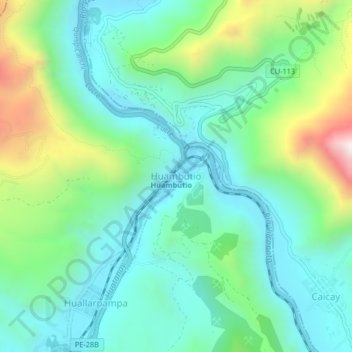
Name: Huambutio topographic map, elevation, terrain.

Location: Huambutio, Lucre, Quispicanchi, Cusco, Perú (-13.60357 -71.73447 -13.56357 -71.69447)

Average elevation: 3,289 m

Minimum elevation: 3,045 m

Maximum elevation: 3,957 m

Other topographic maps

Click on a map to view its topography, its elevation and its terrain.

Huacarpay

Perú > Cusco > Lucre

Average elevation: 3,149 m

Laguna Choquepuquio

Perú > Cusco > Lucre > Huacarpay

Average elevation: 3,150 m

Humedal Lucre - Huacarpay

Perú > Cusco > Lucre

Average elevation: 3,329 m

Gear up for your next adventure:

Bushcraft Tarp - Versatile emergency shelter or gear protection
🩹Compact First Aid Kit - Pre-packed essentials for common trail injuries
🔭Compact Binoculars - Lightweight optics for scouting trails and wildlife
🧴Insect Repellent - Protect yourself from bugs during outdoor adventures
❄️Traction Ice Cleats - Slip-on spikes for icy trails and winter hiking

As an Amazon Associate, this site earns from qualifying purchases at no extra cost to you.